7 David Garneau: A Conversation around “Conflicting Patterns (Salle River Allotments)”
David Garneau and Jérôme Melançon
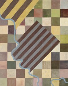
David Garneau, “Conflicting Patterns (Salle River Allotments)”
Oil and acrylic on canvas. 153 x 122cm
Jérôme Melançon: Thanks for sitting down with me and welcoming me into your art studio to discuss the work we’re using for the cover, “Conflicting Patterns (Salle River Allotments).” You’ve told me that this painting is one of your favourites. Why is that?
David Garneau: I love maps. I appreciate their variety and mutability. Political borders change, but so too do cartographic imaginations. Maps that center the oceans or Antarctica, for example, can disorient and re-orient. It wasn’t until my thirties that I saw a map of Edmonton, my home town, from the 1880s. I knew my Metis ancestors had a river lot there then, but I didn’t know that the whole settlement was river lots—and therefore primarily a French/Metis settlement by population and design. The fact that those lots no longer exist, that they were erased by a grid, has a deep and important history.
My great-great-grandparents, Laurent and Eleanor Garneau, bought river lot #7 in 1874. They fled to Edmonton following the first Metis Resistance in Red River (Winnipeg, 1869). Laurent was a soldier in Louis Riel’s provisional army and had to flee after the Resistance was quelled. River lots are narrow strips of land. Their widths and depths vary but all butt up against each other with one width fronting the water. Everyone has access to the river, their houses are relatively close to each other, and they have room for wood lots, gardens and pastures. That map totally rearranged my thinking about Edmonton’s history and had me question the neutrality of the square grid that reorganized the land there and throughout the Prairies. I became intrigued by the idea that although the river lot was rational, like the imperial grid, it is also organic. One side follows the river. The river’s curve causes river lots to distort.
When Canada took over Rupert’s Land in 1867, the government decided to throw a grid over the territory to map, rationalize, contain, and turn it into property. They did so without consulting the land’s inhabitants and stewards, First Nations and Metis Peoples. The Metis were particularly worried that the grid would disrupt their established river lots and land rights. Both Metis Resistances (Red River, 1869, and Batoche, 1885) have their origins in this land dispute. The painting “Conflicting Patterns (Salle River Allotments)” is based on a suspenseful 1867 map. Because the land issue had not yet been settled when the map was made, both the grid and river lots are shown overlapping each other. There is a palimpsest, faint grid lines underneath the existing Metis properties. I painted the map to memorialize the conflict and share that history, but also to indicate the arbitrary nature of political and property divisions. It also reminds us that Metis are implicated as Settlers. Our river lots are settlements.
Jérôme Melançon: In other words the painting relies on the result of the map you found as opposed to the specific location of land boundaries in relation to the river.
David Garneau: Yes. This map—now painting—describes a real place with two spaces: the Metis homeland and its displacement by colonizing Canada. It is also an imaginary space, a re-presentation of a place I have not visited. I also imagine there are numerous histories and lives layered in that real place over time. It is a metaphor for Metis people who are at once not colonizers and yet also settlers. Ultimately, I hope viewers also recognize that river lots and the grids are equally conceptual projections applied to real spaces. Maps not only describe things as they are, they describe intentions, they lay out plans that will alter a place.
Metis people are the offspring of European fathers (French and later Scottish) and First Nations mothers, and their subsequent generations, who were at or deeply entwined with the Red River Settlement in the 19th century. These families understood themselves as a separate people, neither European nor First Nations—though intermarrying and associating with both communities—and were also recognized by those two broad groups as separate. This difference was formally recognized by the revised Canadian Constitution of 1982. Metis are listed there, along with First Nations and Inuit, as an Indigenous people. But even in the late 19th century, the Canadian government recognized the Metis as a separate and prior people who were entitled to land/reparations that were formalized in the issuing of scrip. These land certificates were given to individuals recognized Metis. This is a conservative and political view, one that focuses on Metis as a political organization. A more generous view recognizes extra-political familial and cultural bonds and recognizes ethnogenesis occurring in sites beyond Red River. Laurent Garneau, for example, though he lived in Red River in the 1860s, and who received scrip, was born in the Metis community of Sault Ste. Marie, Michigan.
Jérôme Melançon: I remember how different maps related to Metis history have struck me. Frank Tough gives a series of maps that centre around bodies of water (“As Their Natural Resources Fail.” Native Peoples and the Economic History of Northern Manitoba, 1870-1930, UBC Press, 1996). John Weinstein’s “Recognition of the Métis” map is based on the different manners colonial governments have acknowledged and recognized Metis presence on the territory. Even a simple map like the “Western Canada, Major Cart Trails, Pre 1880s” presented by the Gabriel Dumont Institute gives us a different sense of geography and relation to land. Nathalie Kermoal has spent some time on this idea of trails, drawing on different paintings of yours. And I’ve been taught by Russel Fayant that a more precise map of the Metis homeland would be based on the location of the villages and on the Métis trading routes, so that the homeland isn’t one place that is determined by borders, but rather an overlay of the top of all the different First Nations territories. This would have been made possible by the agreements they had and the arrangements they had with First Nations. It’s also an overlay of the colonial system as well, obviously. This is a very different way to make maps, and to understand where and what a homeland is. This dynamic, this moving or dynamic territory, is difficult to put into one image.
David Garneau: I completely agree. Conventional maps of the Metis homeland do not include Laurent’s community. The most common contemporary map is a large blob-shape covering the Prairie Provinces and slivers of southwestern Ontario, the northern Prairie States, northern BC, and southern NWT. It should include a palimpsest of First Nations territories. A less nationalistic and colonial map would consist of dots representing settlements and lines representing trade and hunting routes, and family connections. There would be a great deal of unclaimed space between. Such territory is claimed by traversing and visiting.
Maps are important devices that not only attempt to describe things as they are but also to picture things and relations the authors hope to realize. Metis are a stateless people. The blob map does not describe our real estate. It is a gentle provocation, a half-hearted land claim. Tough’s mapping makes more sense. It describes relationships among peoples rather than endeavour to establish a conventional nation.
I wrote a paper a while ago called “Migration as Territory: Performing Domain with a Non-colonial Aesthetic Attitude” (2014) that describes our territories as those places we continuously visit. Our territories are not primarily about settled sites but about motion, moving from settled site to settled site. The being between sites, being in motion, the rhythm of settling and unsettling, visiting and departing, is the definition of Metis territory. I can’t imagine a contemporary sense of territory that does not also include the notion of motion and of time, of layers of transit. Cree, Blackfoot, and Stoney Lakota Elders I have spoken with have this sense of time-space. They know they have existed from time-immemorial, but also that there were others here before them. The Cree, for example, only came to the Prairies recently, driven west by the fur trade in the mid-1700s.
The blob map is frustrating because it suggests uniform occupation. A map consisting of Metis dots of settlement and lines of transit would be more accurate. The lines would overlap the claims and experiences of others and the spaces between would belong to no one unless visited. Such maps would have to have to account for time and have colours representing ebbs and flows of occupation. Another map would indicate degrees and types of Metis consciousness!
Jérôme Melançon: Looking more directly at your painting, how did you choose the materials, especially the colours? There is something somber about the colours here which is not unlike certain seasons. Were you trying to reproduce what you saw on the map? Did you have crops in mind?
David Garneau: When did I first see a river lot? I saw maps of them first. Then, I experienced the river lots in Batoche as brush borders dividing a field. I didn’t really understand them until flying over Quebec and seeing how radically different the land was divided there, in seigneuries strips in every direction, rather than the drafting board checkerboard of the Plains. Or even the more rational, parallel river lots of later settlements. Flying over the eastern lots, you can imagine the negotiations property makers would have had with each other and with rivers and other natural barrier to development.
The painting’s colours are earth tones but are not based on life and are not especially symbolic. The stripes echo cloth from that era. I saw similar patterns on fabric in the Royal Alberta Museum and Fort Edmonton heritage site and in Metis beading (especially the “Edmonton knife”). I have since used stripes like this on the Tawatina Bridge paintings. I used stripes to establish the idea that the Metis were not only nomadic—following bison or beavers—but also were settler colonists. They were as organized as their checker boarded neighbours but with a more democratic sense of property. Everyone has equal access to the river while access for the gridded Canadians is inconsistent.
Jérôme Melançon: Then there’s this drive behind it. But the map that you saw in the first place had a very specific function in terms of settlement, and a certain relation to property. It’s part of the claim that is made over the land when you mapped it at that point. When you are painting, what function does your map have? Is it still a map?
David Garneau: In the conceptual stage, and while drawing it on the canvas, it is mostly a map. I am aware that I am assuming/imposing a tabula rasa and inscribing a claim upon the canvas/land. My marks are thin, orderly but unlovely, regular, conceptual. Drawings are by their nature incomplete. They are a wish for more. When painting, I am aware that I am trying to satisfy that wish. I want to evoke a space more richly. Some textures hint at the passage of a combine. Others suggest uneven planting or drying. I am thinking of Paul Klee and his ability to create a space between the decorative and the declarative. The pursuit of beauty sometimes requires a departure from the literal. When dragging viscous colour across a fabric ground, I feel like I am shaping, planting, and tilling the land. My symbolic actions feel implicated in settlement. I am evoking a space, picturing it, but also making it. It is now a real thing not just a representation. The painting occupies space and my intention is that it will leave the studio and enter a public space where its purpose is to manifest Metis presence.
Sometime in the early 90s, I attended Alex Janvier’s walking tour of his exhibition at the Glenbow museum in Calgary. He explained that his abstract paintings of the 1970s were not non-objective paintings but were maps that described his territory around Cold Lake. I once asked him about some of these works that were in an oil company collection. Didn’t he feel conflicted about an oil company that was exploiting and despoiling his territory parading his paintings. He laughed and explained that they didn’t know what was on their walls. He saw them as land claims, reminders that the territory currently occupied by the military and oil companies is Denesuline land. That got me thinking about reclaiming my ancestors passage on these territories. The paintings are a prompt for storytelling.
“Second Exodus (Edmonton to St. Paul des Métis),” 2012, is a companion painting. It is a similarly gridded map showing the Garneau family leaving Edmonton in 1901 for a new Metis-only settlement, St. Paul des Metis. Their passage is a red line ending in settlement dots at either end—Edmonton on the left end and St. Paul des Metis on the right. Between and around the organic passage is the colonial grid that appears to understand all it surveys but does not.
Painting maps feels like participating rather than just picturing. Allowing aesthetic considerations to trump accuracy may be an attempt to free the land from the map. The function of this map painting is to recreate the original map, to bring it out of the drawer or book and into contemporary discourse. It is to make it self-conscious, to reveal its desires and conflicts, which mirror the cartographer’s uncertainty, and our collective anxiety about the “Canada” as an (un)real place.
In this map, I want to show Metis physical resistance. I also want to reveal the strategy of conceptual colonization (through surveying) before the actual occupation, how mapping precedes invasion.
Jérôme Melançon: There’s a political and economic history to this exodus.
David Garneau: My family’s first exodus was from Red River sometime between 1870 and 1874. They fled the military occupation and influx of settlers and harassment of the Metis. The second exodus was when the family of thirteen fled Edmonton for St. Paul des Metis. The need for the settlement demonstrated that city life was intolerable for many Metis. Only collectively could they survive. Laurent died believing that the buffalo and their pre-colonial lives would return. Even though it is just paint on canvas, I can run my finger over these painted maps and imagine their route and reasons.
Jérôme Melançon: And we can feel it just by looking at it. That’s part of the beauty of paintings, what makes them striking. And what’s lacking in reproductions, whether it’s on cement columns or on book covers. It’s not just the aura; it’s also that you can feel the texture by looking at it.
David Garneau: I have mixed feeling too, because I love the digital technology. I post my still life paintings online once a week. I love that they are shared around the world, that they have some presence and affect even if the viewers never see them in the flesh.
There is a suite of Christie Belcourt portrait paintings in the Metis Nation offices in Saskatoon. She paints in a Metis beaded style and the surfaces have a tactile quality. Of course, the Nation doesn’t want the works ruined by many hands touching them. Below each painting is a warning not to touch. Nevertheless, Elders touch the faces of passed Metis Elders and leaders represented in the paintings. To satisfy the urge to touch, the space now has a small beaded painting whose sign reads, “You can touch this one”!
Jérôme Melançon: The first painting of yours I have ever seen was in the Augustana Campus of University of Alberta in Camrose, where we had created this whole space for Indigenous students, and for the campus community as a whole. We had wrapped a series of cement pillars with beautiful works of art, and yours was this vibrant red map, which I thought was just the most wonderful way to really reclaim a space by placing a different map of the territory on it.
David Garneau: Yes. While a few of my larger, “important” paintings—that is works with political and educational content—end up in private collections, most are collected by institutions. A foundational aspect of my practice is to have these paintings in public art galleries, universities, libraries, provincial, federal, and international collections so they will be shared and used. I want them to augment and challenge the content of those collections, shape the way we think of the institutions that house them, change the discourse. And they do!
Jérôme Melançon: You were talking about the map that you made up as opposed to the ones that you reimagined. When you were talking about the correction line, I remembered that this is also what Métis communities did on road allowances. They messed with these colonial constructs, the idea that we need to have roads on the grids no matter what’s in the way. Again, within the colonial logic, it doesn’t matter what is in the way, we will take it anyway. So here was all this “useless” space that didn’t fit this logic.
David Garneau: I wrote about this in a paper called “Road Kill and the Space of the Ditch an Artist Statement.” Southern Saskatchewan has more roads than anywhere on the planet. The grid road system settled the land for agriculture. Property squares were surveyed and fenced leaving margins for later roads. Before they were paved or graveled, dispossessed Metis occupied these strips of unreal estate. The Road Allowance people served the possessors of real estate with their cheap labour. Ironically, theses narrow strips of land resembled river lots—though without the river. I suppose you can see this as a form of resistance or a clever use of useless margins. But I don’t want to romanticize their condition. Road Allowances were allowed because they served colonial capitalism that requires, and therefore manufactures and maintains, a perpetual under-class of precarious workers whose cheap labour can be tapped as needed.
Jérôme Melançon: One aspect of the painting that really struck me, especially as you talked about the work, is the conflict between the patterns of seigneuries or river lots and the cantons, the British square grid, a conflict that featured prominently in the history of Québec I was taught as a child. It’s a matter of modes of property for everyone, but especially for the Metis, because scrip is happening around those same years, where land will be given, but not in according to river lots. The idea is to dispossess a people, to disperse Metis people across communities. There is corruption on the inside to make sure that the Metis people don’t get their land. There’s policy to make sure they don’t get to their land because it’s so far away from their communities. It’s again this difficulty that Metis people had with land, to actually live on the land, as a people.
David Garneau: Yes. The same colonial strategy is being played out with the Indian Residential Schools settlements—individuals are compensated rather than whole groups. The design is to fragment and disperse the collectives. Scrip was a land certificate given to individual Metis by the Canadian government in exchange for their dispossession. Their river lots on prime land were taken away and replaced with pieces of paper. Because they were starving—no Buffalo hunt, no land—most traded their scrip for food. Less than 10% used scrip to get land elsewhere. Scrip not only created the exodus, it also created a social hierarchy. Laurent and Eleanor, and their children all received scrip. Which they traded for land and they prospered. Like their First Nations cousins, Metis communities did not have elaborate differences in rank and wealth. They were collectives. Scrip created unequal opportunities and classes. If you go to Edmonton you can visit the Garneau neighbourhood where you will see the name on many buildings. There are plaques and banners celebrating Laurent and Eleanor. In St. Paul there is a large cairn and plaque in the center of town acknowledging “Garneau Village.”
